Proposed Turnpike Increases Travel Time
(source: FB – NO Turnpikes, Oklahoma!)
The progression of this turnpike is the strongest case yet that the Oklahoma Turnpike Authority has outlived its usefulness, as it is unapologetically producing plans for turnpikes that have only fictional benefit. It is the wild animal kept too long as a pet that inevitably turns on its keeper. Now it consumes us.
On KFOR the other night, one of the reported benefits of this proposed turnpike is that a drive between Tulsa and Dallas will save 50 minutes. I checked it.
Of the three routes Google Maps gave me to drive from Tulsa to Dallas, this proposed turnpike ADDS 20 minutes and 45 miles to the fastest route. The only route it improves upon is the I-44/I-35 route, which it shaves off only 11 minutes and 7 miles from the journey.
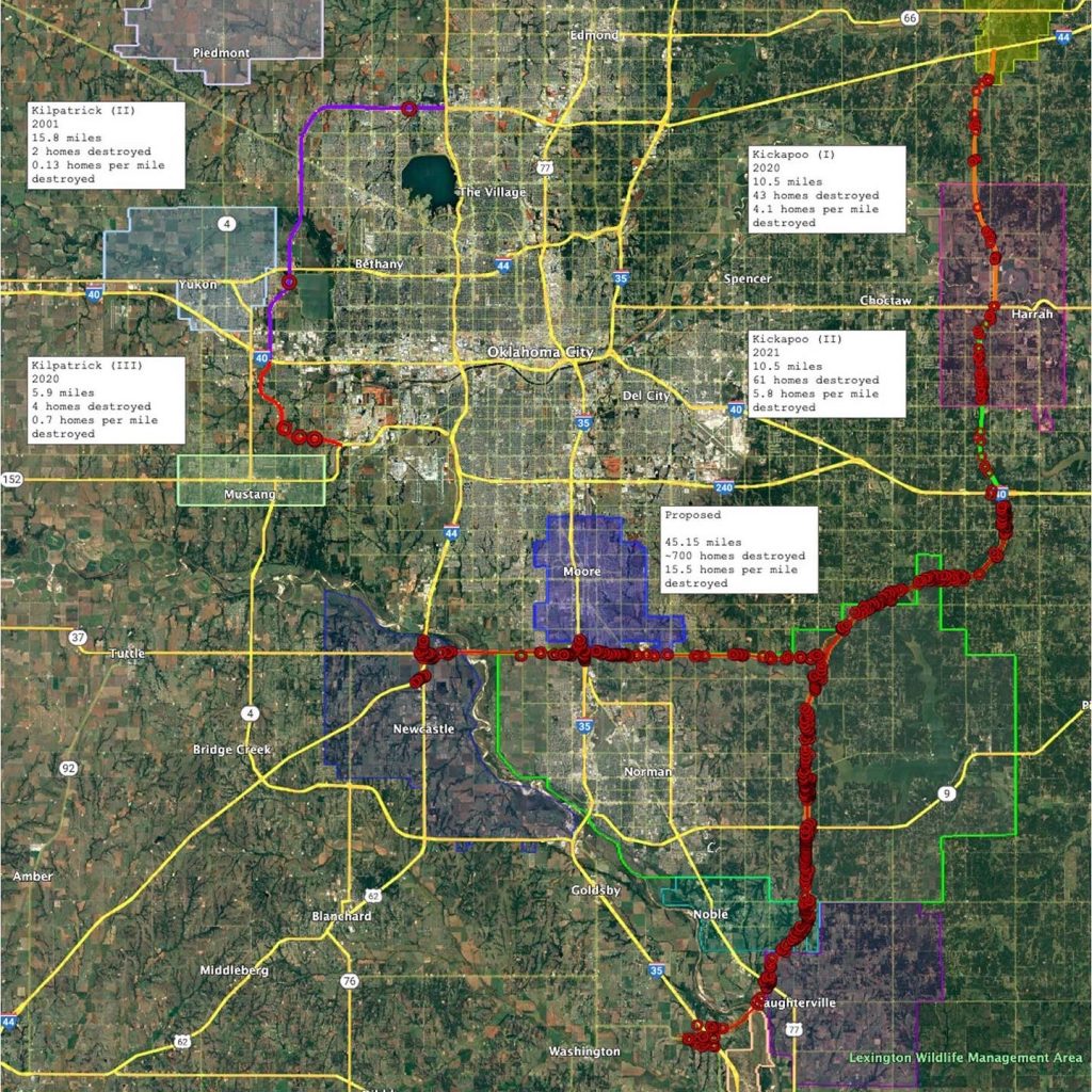
A fully loaded big rig using the proposed turnpike that cuts through Norman, Noble, Slaughterville, and thousands of Oklahomans’ homes will actually consume up to 20 additional gallons of fuel. At best, if traveling the one and only route that this proposed turnpike spares time from, the truck will STILL consume an additional gallon of diesel.
How many trucks and passenger vehicles are going to pay tolls to take longer to get to their destinations? This is just so ridiculous I’m not sure what to think anymore. I need to take a nap.
EDIT: I put my spreadsheet and Google earth files etc in a Dropbox with public link if anyone wants to independently verify my math and methodology. They do their calculations in secret because their product is lies. We need to spread the truth. Maybe a news outlet would be interested to know that the “50 minutes saved between Tulsa and Dallas” is false.

Here’s how you check: Proposed turnpike is about 28.4 miles. Assume 75 mph; 28.4/75 = time B Google maps a route from Tulsa, OK to the i-40 connection of the new pike north of Norman – time A (make sure correct side of road so no weird loops) Google maps a route from the i-35 connection of the new pike south of south of slaughterhouse to Dallas – time C (make sure correct side of road so no weird loops) Time using new pike is time A + time B + time C Now Google maps from Tulsa, OK to Dallas, TX…look at drive times for the options (this is also in screenshot, routed at about 8:50PM)